All Chapter 58 plaques should be updated at the Historical Marker Database.
Here are all the plaques from HMDB.org when “Estanislao” is put in the search field “erected by.” There are 28 plaques altogether.
To see a map of all Clamper plaques, visit htttp://ecvplaques.com . To add missing plaques, go to HMDB.org first, then go to this Google form to request the plaque be added to the map.
Here are just a few of the Chapter 58 plaques:
Empire City
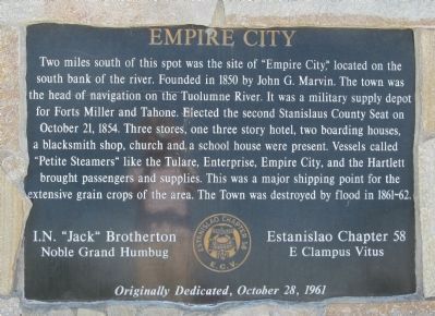
Two miles south of this spot was the site of “Empire City,” located on the south bank of the river. Founded in 1850 by John C. Marvin. The town was head of navigation on the Tuolumne River. It was a military supply depot for Forts Miller and Tahone. Elected the second Stanislaus County Seat on October 21, 1854. Three stores, one three story hotel, two boarding houses, a blacksmith shop, church and a school house were present. Vessels called “Petite Steamers” like the Tulare, Enterprise, Empire City, and the Hartlett brought passengers and supplies. This was a major shipping point for the extensive grain crops of the area. The town was destroyed by flood in 1861-62.
I.N. “Jack” Brotherton – Nobel Grand Humbug
Estanislao Chapter 58
E. Clampus Vitus
Originally Dedicated, October 28, 1961
Location: 37° 38.316′ N, 120° 53.894′ W. Marker is in Empire, California, in Stanislaus County. Marker can be reached from First Street near Yosemite Boulevard (California Highway 132). Marker is located at Empire Park, at the eastern end of the parking area. Touch for map. Marker is at or near this postal address: 2 First Street, Empire CA 95319, United States of America. Touch for directions.
La Grange
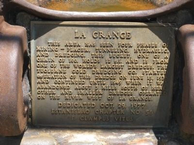
This area has seen four phases of mining – placer, tunneling, hydraulic, and dredging. This bucket, one of a chain of 100, holds 12 c.f. and is from one of the worlds largest dredges. The Tuolumne Gold Dredging Co. started operation of the dredge on June 15, 1938 and continued until 1949 when it was abandoned about 3 miles south of here. Other and smaller dredges operated on this river west of La Grange.
Erected 1977 by Estanislao Chapter 58, E Clampus Vitus.
Location: 37° 39.828′ N, 120° 27.63′ W. Marker is in La Grange, California, in Stanislaus County. Marker is on Yosemite Boulevard (State Highway 132), on the left when traveling east. Marker is located at the small La Grange Historical Park. Touch for map. Marker is at or near this postal address: 30173 Yosemite Boulevard, La Grange CA 95329, United States of America. Touch for directions.
Roberts Ferry
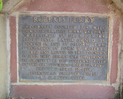
Originally located 3/8 mile downstream, this ferry was first established by Dr. B. D. Horr about 1850. Later owned by Dickenson and by Osborn, it was purchased by John W. Roberts in 1862 and moved to this location in 1865. The ferry was the principal crossing of the Tuolumne River on the old Stockton-Mariposa Road.
Erected 1966 by Estanislao Chapter 58, E Clampus Vitus.
Location: 37° 38.312′ N, 120° 37.117′ W. Marker is in Roberts Ferry, California, in Stanislaus County. Marker is at the intersection of Yosemite Boulevard (State Highway 132) and Roberts Ferry Road, on the right when traveling east on Yosemite Boulevard. Touch for map. Marker is in this post office area: Waterford CA 95386, United States of America. Touch for directions.